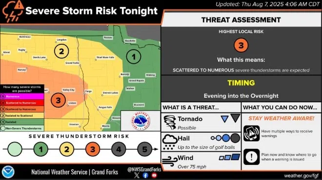
Forecast for severe storms on Thursday, August 7, 2025 from the National Weather Service in Grand Forks, North Dakota.
The National Weather Service has issued a Level 3 storm threat advisory for much of eastern and central North Dakota.
Severe storms are possible throughout the upper Midwest today, with the entirety of North Dakota and Minnesota expected to be impacted. The most severe weather is forecast in the southern section of North Dakota between Fargo and Bismarck. Stutsman County and Jamestown are in the center of the most severe forecasts. Extreme winds and hail up to the size of baseballs could impact the area, and conditions could be conducive to tornado formation, according to the NWS.
This system could rapidly intensify, but remains unpredictable.
Officials urge residents to have a plan for shelter if a warning is issued and have multiple ways to receive emergency alerts. Due to the unpredictability of power loss, you are also advised to charge cell phones and batteries before the storms arrive.
KSJB Radio will continue to update you throughout the day on the latest projections we receive from the National Weather Service.


Comments